SOLD – For Sale: Timberneck Farm
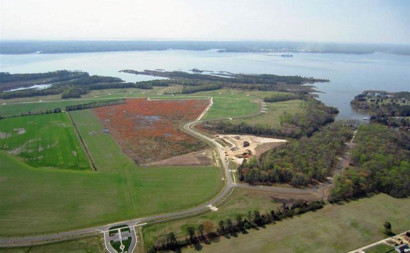
Our vision is to develop Timberneck Farm as a preservation development blending the historical, agricultural, recreational, ecological, marine and wildlife resources into a low-density community that will replicate rural farm life on the Virginia Middle Peninsula by surrounding active farmland with architecturally controlled waterfront and waterview homesites.
Located in Gloucester County on the northern banks of the York river, Timberneck encompasses 644± acres within 10 minutes of historic Yorktown and 30 minutes from Williamsburg via the Colonial parkway. Gloucester County’s history actually dates from just after the 1607 settlement of Jamestown when settlers explored the Virginia Peninsula and crossed the York into what is now the county. Chief Powhatan’s fortress was located very near Timberneck Farm and more likely than not he frequently traversed the land. Gloucester Point, just a short boat ride down river and just across the river from Yorktown, is the site of the “Second Surrender” by General Charles Lord Cornwallis to General George Washington in 1781.
Timberneck Farm’s development encompasses the spirit of the Gloucester’s current motto of “The land of the life worth living” and as proclaimed by Captain John Smith “Heaven and Earth never framed a better place for man’s habitation”. Rising quickly above and overlooking more than 400 acres of perpetually protected islands and marshland adjacent to the York and Poplar Creek known as the Catlett Islands, the highland of Timberneck Farm is bounded on the east by Timberneck Creek. Located around the perimeter of the highland outside of the rural farm road on naturally created points and banks are a limited number of wooded waterview and waterfront homesites, as well as open and wooded walking trails and observation decks overseeing portions of the Catlett Islands and beautiful sunsets.
The broad expanse of the York River shapes the very identity of Timberneck Farm. The York and its tributaries bound the Farm on three sides, providing a spectacular yet profoundly peaceful backdrop for a limited number of waterfront and waterview homesites.
One of America’s most historic waterways, the York today is an ecological jewel that is home to a rich collection of wildlife living in hundreds of acres of perpetually protected islands and marshlands adjacent to the property.
The development plan of Timberneck Farm embraces its waterfront through careful and respectful planning. A private boat landing will exit on Timberneck Creek, providing easy passage to the York River. In addition, many of the homesites are eligible for private boat docks, providing residents with their own access to this great American river.
Timberneck Farm presents a rare opportunity to live amidst the preserved and protected lands adjacent to Virginia’s York River. Residents enjoy both the responsibility and the privilege of securing a place within the stunning riverscape and farmland of the historic peninsula.
SOLD – For Sale: 2 Acre Lot With Long Frontage on Craig Road
Close to Downtown – 2 Acres open with long frontage on Craig Rd. Great development potential. Zoned RM-1. Water & Sewer available. Owner is Realtor. The purpose of the RM-1 and RM-2 Districts is to allow for a mix of single-family detached, single-family attached, two-family, townhouse, and multifamily dwellings in order to provide a range of housing choices.
Zoning Code: RM-1
Tax ID: 3240118
Annual Taxes: $411
Manufactured Allowed: Yes
Road Frontage: 460
Schools
Elementary School: Monterey
Middle School: Lucy Addison
High School: William Fleming
Directions
Rt. 460-E to Left on Hollins Rd. Right on Mason Mill Rd. to Left on Craig Rd. Property on Left.
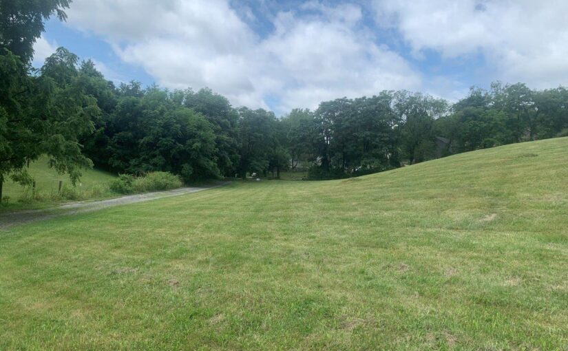
SOLD – For Sale: 6 Acres on Boones Mill Road
Boones Mill 6 acres, NO RESTRICTIONS, come do what you please on your new 6 acres. Sellers have clear cut the timber on this parcel so you can see exactly what you are buying. Finish clearing what you want open and replant what you want trees on. Several nice building sites. Nice view from the highest point. Lots of potential and again NO RESTRICTIONS!!!!!
Zoned A-1
Assessed for $50,100. New survey and perked.
16 miles from downtown Roanoke
Tax ID: 0260017100 part
Annual Taxes: $274.50
Schools
Elementary School: Boones Mill
Middle School: Ben Franklin Middle
High School: Franklin County
Directions
From 419/Franklin Rd at Tanglewood Mall take 220 South to Boones Mill. Turn left and then right on Boones Mill Rd. Go 1.2 mi to prop on left. Also turn left on Harmony Rd and prop is on the left.
SOLD: For Sale: Private 14 Acres on Smith Mountain Lake
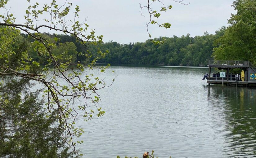
Amazing waterfront property close to Roanoke, deep water, main channel & views. 765′ of water frontage at the 795. Only 12 miles to Downtown Roanoke. This hidden jewel has not been on the market since the early ’80’s. There is an existing septic system that is serving 2 mobile homes & 2 wells. With a little clearing, great views. This property is an amazing secluded gem. Privacy, new survey (being completed now) and is only limited by your imagination. This is a clean canvas waiting on your touches.
Tax IDs: 040101600 & 0040002701A
Schools
Elementary School: Windy Gap
Middle School: Ben Franklin Middle
High School: Franklin County
6200 Hardy Road, Hardy Va. Look for orange flagging on gate for entrance.
Gate is locked and a combination is required for access.
Directions
From Vinton: Take Hardy Rd to property on L at 6200 Hardy Rd. Just past vineyard; look for orange flagging on gate. Gate will be on L prior to 6200. From Halesford: gate will be just past GPS arrival.
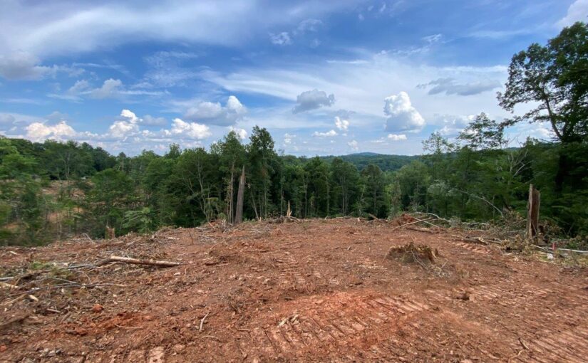
SOLD – For Sale: 91± Acres
This end of the road property is a hard to find secluded gem. Privacy & seclusion are top of the list here. Located at the very end of Finch Lane a private drive you will find your freedom. The timber has been harvested. This means the under story of the forest is free to grow & regenerate the new forest. This will make it thick for humans to walk BUT is what the wildlife is looking for. Come share your space with the deer, bear & turkeys. Wonderful pond site & as you can see on the topo & you will also see where there is an old homestead foundation nestled just above the stream, I’m sure by spring. Come build your homestead where the old-timers chose years ago. Owner has opened a trail around the property and seeded it in grass. Bring your side by side, four wheeler, trusty steed or
strap on those hiking boots & take a look. Long range mountain views are here. Property has a new survey & the lines have been painted. Come enjoy the seclusion! This is an awesome find for land at this price. Great hunting property.
Seller is Owner/REALTOR
Tax ID: 0910008700
Annual Taxes: $622.2
Manufactured Allowed: Yes
Schools
Elementary School: Henry
Middle School: Ben Franklin Middle
High School: Franklin County
Directions
From 220-S: turn Right on 619,Pleasant Hill. Turn Left on Providence Church. Then Left on Fork Mountain. Turn Left on Finch Lane. On Finch, go to end at red gate across road. Open gate & go through. At next red gate, turn Left before gate, & continue to 2 chain link fence gates. When you enter here, you’re on the property. Go into chain link gates, bear left, cross gas line & go to log landing area. If going with side-by-side, start back toward gate & take first Left on the pushed road. This will take you basically around the whole place.
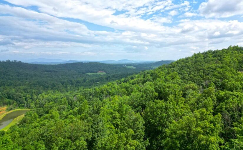
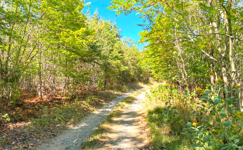
SOLD – For Sale: 53.12± Undeveloped Acres
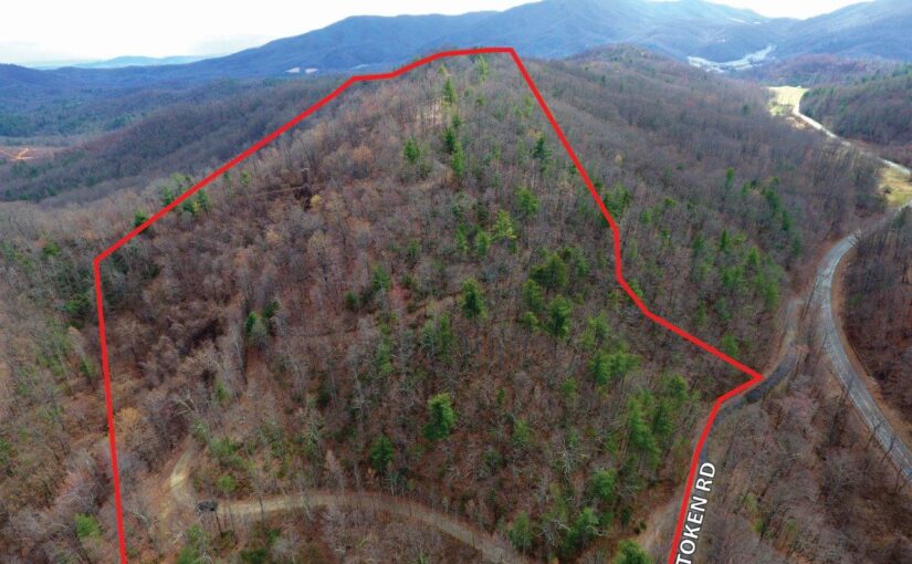
Don’t miss the opportunity to own 53.125 acres located in SWCO just minutes from the Tanglewood mall area, schools, shopping and other amenities.The property offers long ranging views, abundant wildlife, diverse habitat, and a wide interior road making the property easily accessible. Build your dream home or enjoy this wonderful recreational tract that feels secluded, but is only minutes from town. This property has multiple build sites (see cleared area top of ridge) and is in a highly desired school system. See docs for soil report (perc for 4 bedroom).
Tax ID: 106.00-02-42.03-0000 & 106.00-02-41.00-0000
Schools
Elementary School: Penn Forest
Middle School: Cave Spring
High School: Cave Spring
Directions:
From Downtown Roanoke: 220-S 2.5mi & exit to 419-N. in 0.8mi, take L on Starkey Rd. 1.6mi turn R on Starkey Rd. Then L on Merriman Rd. 0.5mi take R on Merriman Rd. In 1.8mi go L on Token. Drive on R.
SOLD – For Sale: 53± Acres of Vacant Land Close to Lynchburg
53± Acres of vacant land close to Lynchburg. Just off Hwy 29 & an easy commute with privacy. Right-of-way road dissects the property. County water is on Galts Mill Rd. If you are looking for country living, but still close to town, this is your place. Small portion of Juniper Creek crosses the property. Timber has been harvested. Survey, topo, and aerial in documents. Property is in land use & receives discounted taxes. Make sure to look at the topo map, although it’s thick, the topography is nice.
Tax ID: 157-A-152A
Annual Taxes: $130.54
Schools
Madison Heights Elementary
Monelison Middle
Amherst High
Directions
Galts Mill Rd. to Right on Juniper Farm Rd., then proceed to sign. Put Juniper Farm Rd., Madison Heights, VA in your phone & look for signs.
SOLD – For Sale: 41.15 Acres -Privacy, Mountain Views, Adjoins Jefferson National Forest

This large 41.146 acre tract offers a great ridgetop build site, which would provide views of surrounding mountains such as McAfee Knob, Purgatory Mountain, & other notable mountain ranges. Enjoy the seclusion this property offers while still being within minutes of two different interstate exits & just 35 minutes from Lexington & 30 minutes from Downtown Roanoke. Successful Perc test for 4 Bedroom house at potential build site. Road frontage along Lithia Rd & Fringer Trl. Don’t miss the opportunity to build your dream home or own a great recreational property with hunting, biking along the 76 Bicycle Route (Lithia Rd), Jefferson National Forest right across the street, & much more. Property is in Land Use.
Tax ID: 76-76
Annual Taxes: $935
Manufactured Allowed: Yes
Schools
Elementary School: Buchanan
Middle School: Central Academy
High School: James River
Directions
Take I-81 N to Exit 156, then R on Brughs Mill Rd. In 0.4mi turn L on Rte.11. In 2.4mi, turn R on Blue Ridge Tpke. At stop sign, keep L to Lithia Rd. Go R in 3.3mi on Fringer Trl & property on L.
SOLD – For Sale: Chestnut Flats Mountain Haven – Estate of Frank Hardy, Jr.
111 acres minutes from Historic Lewisburg, West Virginia and Greenbrier Valley Airport.
High mountain plateau that affords privacy and spectacular views of the surrounding mountains in many directions. A good mix of open fields and woods with native flora and fauna. Improvements include a 40 x 80 metal building with office, bath, water and septic. Live in the shop while building your dream home.
If you are into hiking, recreation or just enjoying beautiful views this is your place. Come enjoy the long range mountain views or just sit quietly above the pond and take in the sights and sounds.
For an additional $60,000 purchase the existing high quality woodworking and metal working equipment which includes complete paint booth, welding booth, air compressor and dust collection system. Itemized list available upon request.