For Sale: Top of the Mountain Retreat – 349± Acres
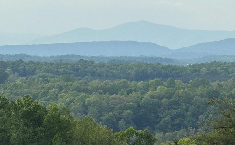
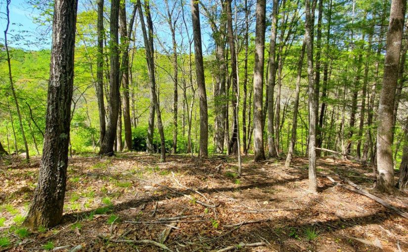
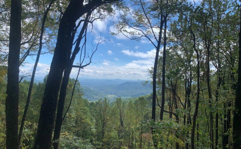
Top of the Mountain Retreat – 349± Acres. Here’s your chance to own a rare & expansive mountain property at the very end of a paved county road—your own private oasis with a locked gate & endless possibility. This ±349-acre tract boasts long frontage on Big Chestnut Creek, a striking, bold stream that resembles a river as it winds through the land. The sound of rushing water & the stunning creek-side views create a truly peaceful, natural setting. On the Taylor Tyree Road side, you’ll find approximately 14 acres (being surveyed now). Build your cabin on the Taylor Tyree side and enjoy your recreation across the creek. This portion of the land also offers mature timber.
The remaining 335 acres lie across Big Chestnut Creek, accessible either by a ford from within the property or via a recreational and logging easement through well-managed timberland off Chestnut Mountain Road. Roughly 2/3 of this section has been timbered within the last 4 years, offering a blank slate for new timber management plans. The remaining 1/3 features standing timber & mature hardwoods, yours to manage as you see fit.
With incredible mountain views, diverse terrain, and multiple potential cabin sites, this property offers endless opportunities for:
-Recreational use (hunting, hiking, ATV riding)
-Long-range shooting
-Timber investment
-Off-grid living or a family compound
Don’t miss the chance to own this sought-after, large mountain boundary. The combination of natural water features, privacy, views, and access make this one truly special.
The land across Big Chestnut Creek is in Land Use, the piece on Taylor Tyree is not. All Property in non-zoned section of County.
Tax ID: Portion of 0890000900, 902, 1200, 1300
Schools:
Elementary School: Snow Creek
Middle School: Ben Franklin Middle
High School: Franklin County
Directions:
From Rte 40 at Glade Hill on Colonial Tpke: go Left on Taylor Tyree Rd. From US-220 S of Rocky Mt., turn East on Sontag Rd. Go Left on Colonial Tpke, then Right on Taylor Tyree. Property is at end.
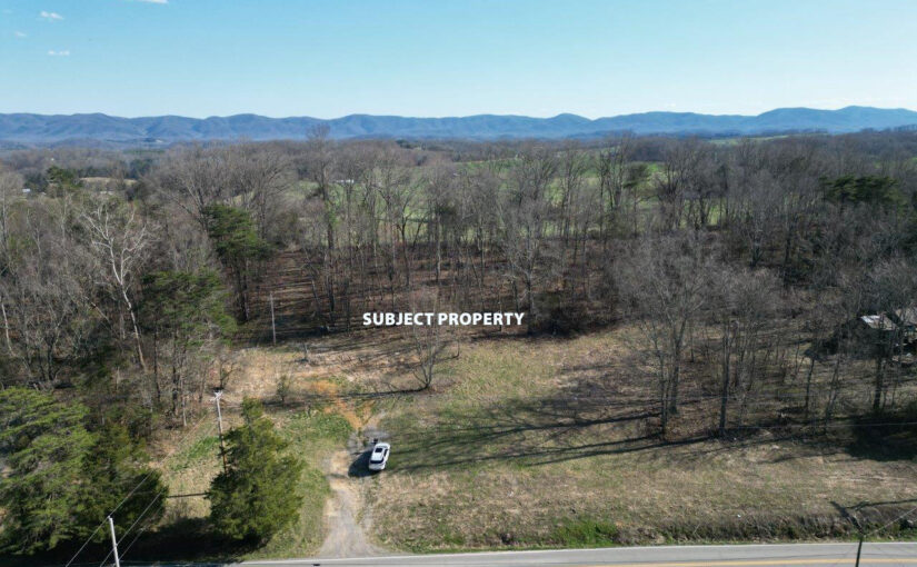
For Sale: New Construction Mountain Chalet with Breathtaking Views
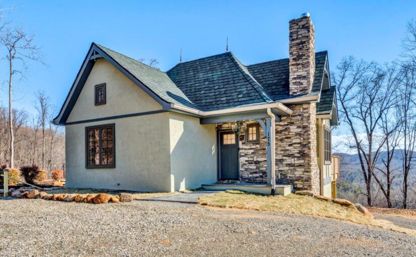
New Construction Mountain Chalet with breathtaking views! Don’t miss out on this one-of-a-kind home and property located in Franklin County just across the Roanoke County line and only 20 minutes from downtown Roanoke. This newly constructed custom-built home features vaulted ceilings on the entry level, two kitchenettes, two bedrooms, two full bathrooms, Pella windows, gas log fireplace, large deck with hot tub, tankless propane water heater, outdoor fireplace; all situated on a secluded 15± acres. Enjoy all the privacy Franklin County has to offer while sipping your morning coffee and watching the sun rise over the mountains. House designed to be suitable for short-term rental (Special Use Permit required). Follow the driveway beyond the house to another area that would make a fabulous build site for your dream home and use the chalet as a home/guesthouse for family (Refer to aerial under documents to see potential build site location). Property has potential for a vineyard or orchard. Come take a look today!
Year Built: 2024
Construction Status: Completed
Total Acreage: 15.01±
Zoning Code: A1
Tax ID: 0200003202
Annual Taxes: $893.11 (Estimated by Agent)
Entry Above Ground Finished SF: 544±
Lower Below Ground Finished SF: 576±
Total Above Ground Finished SF: 544±
Total Finished SF: 1,120±
Grand Total Attached SF: 1,120±
Total Bedrooms: 2
Total Full Baths: 2
Basement: Walkout – Full
Schools
Elementary School: Boones Mill
Middle School: Ben Franklin Middle
High School: Franklin County
Directions
From Boones Mill: Travel North on Rt.220 for 1.8 miles & turn Left onto Naff Rd. Travel 0.9 miles & turn Right onto Guthrie. Travel 0.6 miles & turn Right into driveway – Hayden Mtn Rd.
For Sale: Private and Secluded 0.556 Acre Lot in SWCO
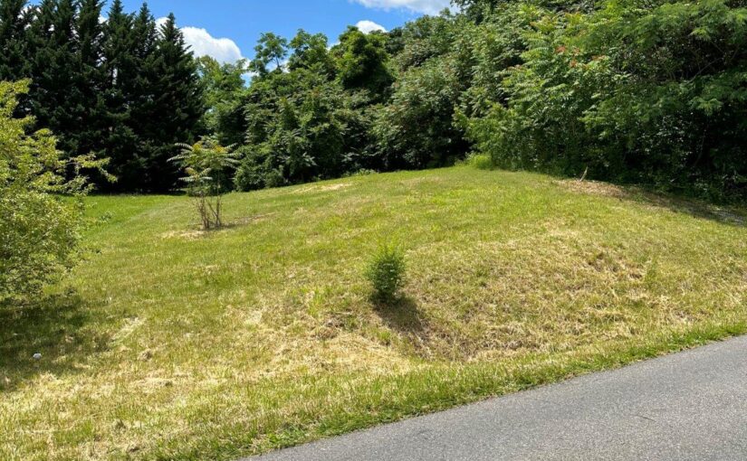
This private and secluded .556-acre lot is ideal to build your new home in a great SWCO location and located on corner of Willow Spring Rd and Crystal Creek Rd. This wooded tract has a great build site area and has already been perked for a 3 bedroom home. You can hear Back Creek flowing in the distance. This lot is in a highly desired school system and only minutes to schools, shopping and other area amenities. Don’t miss this rare opportunity. Call today for more information.
Zoning Code: R-1
Tax ID: 086.20-02-13.01-0000
Annual Taxes: $381.6
Schools
Elementary School: Penn Forest
Middle School: Cave Spring
High School: Cave Spring
Directions
221 (Brambleton Ave) to Left on Crystal Creek to Left on Willow Spring Rd. Lot on right.
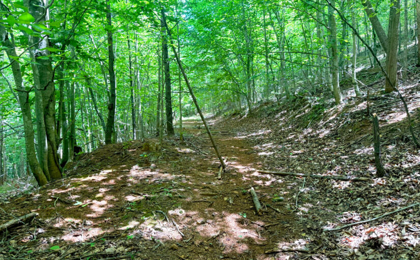
SOLD – For Sale: Premier 28± Acre Wooded Mountain Tract
A premier wooded mountain tract only 12 miles to Roanoke. Great care was taken to preserve the mature forest. Only trees removed were for upgrading the existing driveway, improving the level building site and revealing the views to the distant mountain ranges. Privacy is ensured with Blue Ridge boundary on 2 sides and large tracts boundaries on the rest. There are additional hiking and utility vehicle trails accessing all areas of the 28 acres. Several spring fed streams flow along the outer boundaries. Also, past the building site accessed by hiking/ UTV SUNRISE POINT offers a great primitive campsite. Unrestricted to allow the new owner unlimited possibilities to enjoy as they want. Owner/Realtor.
Land Sub-Type: Undeveloped
Total Acreage: 28.28
Tax ID: 0210000900
Annual Taxes: $621 (Estimated by Agent)
Manufactured Allowed: No
Schools
Elementary School: Back Creek
Middle School: Cave Spring
High School: Cave Spring
Directions
From Roanoke: Rt. 221-S to Left on Slings Gap Rd. (at Bent Mountain Fire Station). Take Slings Gap for 2mi. Property is driveway on Right after Blue Ridge Parkway underpass.
SOLD – For Sale: 0.27± Acre Lot With 97 Feet of Road Frontage
This 0.27 acres with 97-feet of road frontage, easy access to 581, and R-7 zoning makes it the perfect build site for your dream home.
Land Type: Land (Acreage)
Land Sub-Type: Residential – Single Family
Total Acreage: 0.27
Lot: R2
Block: 3
Section: 0
Zoning Code: R-7
Tax ID: 6490302
Annual Taxes: $856 (Estimated by Agent)
Manufactured Allowed: No
Schools
Elementary School: Round Hill
Middle School: James Breckinridge
High School: William Fleming
Directions
From Downtown Roanoke: Take I-581 North to the second Peters Creek Rd. exit, then left onto Frontage Rd. Lot is on Right.
SOLD – For Sale: 49 Undeveloped Acres – Close to Salem and Christiansburg
Quiet retreat awaiting your imagination. Owning both sides of Lavender Road offers limitless possibilities. Climb the mountain & get the view! Hunting & Recreation awaits. There is a network of old logging roads for hiking or ATV’s. This is a nice setting very close to Salem or Christiansburg. There are only three houses on Lavender Road, so come find your seclusion. See pictures & the aerial with the tract line is my walking trail. Lots of other roads not mapped. Here is your chance to buy land at $2,000 an acre. Don’t miss out!
49± Wooded Acres
Lot: 1 & 2
Tax ID: 020087
Annual Taxes: $555
Manufactured Allowed: Yes
Schools
Elementary School:Eastern Montgomery
Middle School:Shawsville
High School:Eastern Montgomery
Directions
Rte.11 in Shawsville, VA turn south on Alleghany Spring Rd/SR 637. Go 3.7mi, turn right on Mt Pleasant Rd/SR639. Go 1.9mi, turn left on Lavender Rd. Approx. 3/10mi to Property & 5/10mi to Left entry.
SOLD – For Sale: Picturesque 5 Acres
Beautiful country setting and 5 acres of privacy. Surrounded by farms, this picturesque 5 acres offers wonderful building sites and is an easy commute to Fincastle or just minutes to I-81 at Exit 162 for a quick trip to Roanoke. Well and Septic in place, all you need are building plans and imagination.
Tax ID: 62-106
Annual Taxes: $474.79
Schools
Elementary School: Breckinridge
Middle School: Central Academy
High School: James River
Directions
From I-81 at Exit 162: turn South on Rt.11/Lee HWY, then turn Right on Wheatland Rd. Proceed to property on Left. From Fincastle on Springwood Rd: turn Right on Wheatland & property will be on Right
SOLD – For Sale: 7± Acres With Panoramic Mountain Views And Gills Creek Frontage
Build your dream home on this private 7± acres with panoramic mountain views and frontage on Gills Creek only 20 minutes from downtown Roanoke! This incredible fenced 7 acres of undeveloped land is mostly open with gentle sloping topography. A rare opportunity!
Total Acreage: 7.04±
Zoning Code: A1
Tax ID: 0180007300
Annual Taxes: $240 (Estimated by Agent)
Manufactured Allowed: Yes
Acres Cleared: 3.5±
Acres Wooded: 3.5±
Schools
Elementary School: Windy Gap
Middle School: Ben Franklin Middle
High School: Franklin County
Directions
From Downtown Roanoke: take VA-116 over Windy Gap Mountain, then a Right onto Boones Mill Rd. and Left on Red Valley Rd. to property on Left.
SOLD – For Sale: Timberneck Farm
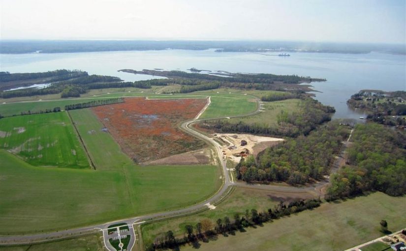
Our vision is to develop Timberneck Farm as a preservation development blending the historical, agricultural, recreational, ecological, marine and wildlife resources into a low-density community that will replicate rural farm life on the Virginia Middle Peninsula by surrounding active farmland with architecturally controlled waterfront and waterview homesites.
Located in Gloucester County on the northern banks of the York river, Timberneck encompasses 644± acres within 10 minutes of historic Yorktown and 30 minutes from Williamsburg via the Colonial parkway. Gloucester County’s history actually dates from just after the 1607 settlement of Jamestown when settlers explored the Virginia Peninsula and crossed the York into what is now the county. Chief Powhatan’s fortress was located very near Timberneck Farm and more likely than not he frequently traversed the land. Gloucester Point, just a short boat ride down river and just across the river from Yorktown, is the site of the “Second Surrender” by General Charles Lord Cornwallis to General George Washington in 1781.
Timberneck Farm’s development encompasses the spirit of the Gloucester’s current motto of “The land of the life worth living” and as proclaimed by Captain John Smith “Heaven and Earth never framed a better place for man’s habitation”. Rising quickly above and overlooking more than 400 acres of perpetually protected islands and marshland adjacent to the York and Poplar Creek known as the Catlett Islands, the highland of Timberneck Farm is bounded on the east by Timberneck Creek. Located around the perimeter of the highland outside of the rural farm road on naturally created points and banks are a limited number of wooded waterview and waterfront homesites, as well as open and wooded walking trails and observation decks overseeing portions of the Catlett Islands and beautiful sunsets.
The broad expanse of the York River shapes the very identity of Timberneck Farm. The York and its tributaries bound the Farm on three sides, providing a spectacular yet profoundly peaceful backdrop for a limited number of waterfront and waterview homesites.
One of America’s most historic waterways, the York today is an ecological jewel that is home to a rich collection of wildlife living in hundreds of acres of perpetually protected islands and marshlands adjacent to the property.
The development plan of Timberneck Farm embraces its waterfront through careful and respectful planning. A private boat landing will exit on Timberneck Creek, providing easy passage to the York River. In addition, many of the homesites are eligible for private boat docks, providing residents with their own access to this great American river.
Timberneck Farm presents a rare opportunity to live amidst the preserved and protected lands adjacent to Virginia’s York River. Residents enjoy both the responsibility and the privilege of securing a place within the stunning riverscape and farmland of the historic peninsula.
SOLD – For Sale: 2 Acre Lot With Long Frontage on Craig Road
Close to Downtown – 2 Acres open with long frontage on Craig Rd. Great development potential. Zoned RM-1. Water & Sewer available. Owner is Realtor. The purpose of the RM-1 and RM-2 Districts is to allow for a mix of single-family detached, single-family attached, two-family, townhouse, and multifamily dwellings in order to provide a range of housing choices.
Zoning Code: RM-1
Tax ID: 3240118
Annual Taxes: $411
Manufactured Allowed: Yes
Road Frontage: 460
Schools
Elementary School: Monterey
Middle School: Lucy Addison
High School: William Fleming
Directions
Rt. 460-E to Left on Hollins Rd. Right on Mason Mill Rd. to Left on Craig Rd. Property on Left.